Kumamoto Prefecture
| Kumamoto Prefecture | |||||||||
|
|||||||||
 |
|||||||||
| Capital | Kumamoto | ||||||||
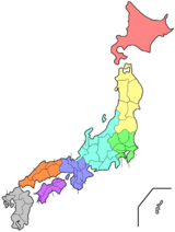
| Region | Kyūshū | ||||||||
| Island | Kyūshū | ||||||||
| Governor | Ikuo Kabashima | ||||||||
| Area (rank) | 7,404.14 km² (16th) | ||||||||
| - % water | 0.2% | ||||||||
| Population (October 1, 2005) | |||||||||
| - Population | 1,842,140 (23rd) | ||||||||
| - Density | 249 /km² | ||||||||
| Districts | 10 | ||||||||
| Municipalities | 48 | ||||||||
| ISO 3166-2 | JP-43 | ||||||||
| Website | www.pref.kumamoto.jp/ english/list.html |
||||||||
| Prefectural symbols | |||||||||
| - Flower | Gentian (Gentiana scabra var. buergeri) | ||||||||
| - Tree | Camphor tree (Cinnamomum camphora) | ||||||||
| - Bird | Eurasian Skylark (Alauda arvensis) | ||||||||
| - Fish | {{{Fish}}} | ||||||||
 Symbol of Kumamoto Prefecture |
|||||||||
| Template ■ Discussion ■ WikiProject Japan | |||||||||
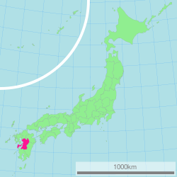
Kumamoto Prefecture (熊本県 Kumamoto-ken) is a prefecture of Japan located on Kyūshū Island. The capital is the city of Kumamoto.
Contents |
History
Historically the area was called Higo Province and was renamed to Kumamoto Prefecture during the Meiji Restoration as part of the abolition of the feudal system. The current Japanese orthography for Kumamoto literally means "bear root/origin", or "origin of the bear".
Geography
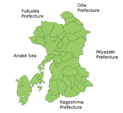
Kumamoto Prefecture is located in the center of Kyūshū, the southernmost of the four major Japanese islands. It is bordered by the Ariake inland sea and the Amakusa archipelago to the west, Fukuoka Prefecture and Ōita Prefecture to the north, Miyazaki Prefecture to the east, and Kagoshima Prefecture to the south.
Mt. Aso (1592 m), an extensive active volcano, is in the east of Kumamoto Prefecture. This volcano is located at the center of the Aso caldera, the most famous caldera in Japan.
Cities
Fourteen cities are located in Kumamoto Prefecture:
- Amakusa
- Arao
- Aso
- Hitoyoshi
- Kami-Amakusa
- Kikuchi
- Kōshi
- Kumamoto (capital)
- Minamata
- Tamana
- Uki
- Uto
- Yamaga
- Yatsushiro
Towns and villages
Towns and villages in each district:
|
|
|
Mergers
Economy
Kumamoto hosts a large Honda automobile plant. In 2007, a Honda factory on the site began to produce non-silicon solar cells for homes and businesses, with a projected capacity roughly equivalent to 8,000 households/year.[1]
Demographics
Tourism
Kumamoto's main tourist attractions consist of Mt. Aso, one of the worlds largest active volcanoes, Kumamoto castle and Suizenji park. There is also a Mitsui Greenland amusement park in Arao.
Prefectural symbols
Sister cities
- Kumamoto Prefecture is the 'sister state/prefecture' of Montana in the United States[2]
Notable people
- Kumamoto is the birthplace of Hollywood actor Tetsu Komai and filmmaker Kazuaki Kiriya, J-pop artist Kimeru, as well as J-Pop musician Tomiko Van.
External links
- Official Kumamoto Prefecture homepage
- Kumamoto Links
- Wikitravel guide to Kumamoto Prefecture
- National Archives of Japan ... Kumamoto map (1891)
|
||||||||||||||
|
|||||||||||||||||||||||||||||||||